Even though I couldn’t attend RootsTech, I was inspired with several great ideas for family history. One was using Google Maps to geotag family history locations and then share it with my family. It’s really simple to set up and especially easy to use with your GPS enabled phone.
Set up the map

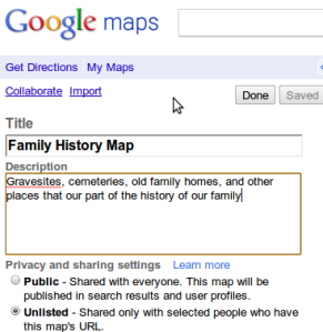
The first step is to sign in to your Google account and go to maps. At the left of your screen is an option for ‘My Maps’–choose this. Now you can create your own map and choose to share it with the world (public) or keep it private for just your family (unlisted). I keep mine unlisted. Give it a title and description and your ready to start adding to your new map.
Geotagging
You can actually mark sites from your computer or your phone by using this method. For marking graves when you can get to the cemetery, probably easier to mark the grave with GPS phone. But what about cemeteries too far away for a trip or Grandma’s old house you visited as a kid? You can mark these from home. Let’s look at both ways.
From your computer…
Drag the blue marker (seen at the top of the screen) to your site. Here I’ve marked a cemetery near downtown Sacramento, CA. You can use the cemetery name for the title,
but I like to use the name of the person most closely associated with the spot. The marker titles will display in a list in the left frame. For me, it’s easier to sort through people than place names I might not remember. When you have a cemetery where multiple relatives are interred you can simply use a surname for the title and then list the names of each in the description.
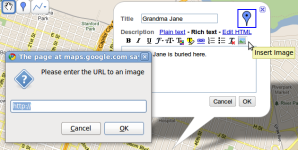
 You can even insert an image to go along with the site. Google won’t store your image file, but will allow you to link to an image for use. This is another great use for your Flick account. In the bubble, click on Rich Text, then the insert image icon and paste a link to your image. It’s that simple. Click OK and your image is linked and your location is saved.
…or from GPS/Phone

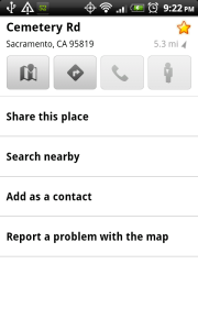
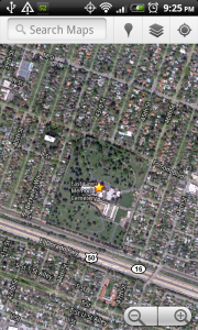
 I use an Android phone and I couldn’t possibly recommend it more. Google Maps comes standard with every Google phone and does a good job of tagging locations. Make sure your GPS is on and then simply touch the compass icon at the top right to center on your current position. Long press on the spot you want to tag and you’ll see a bubble with your location–touch it. This screen gives you a number of options, but what we’re interested in is the star in the top right corner. When you touch it you’ll see it glow bright yellow. This location is now saved to your Google Maps account. It was that easy. OK, not quite that easy. Once you get back to your laptop/desktop you’ll need to log in to you Google Maps account. When you do so, you’ll see all your starred locations. Click on each star and save that location to your Family History map. You’re in business.
 What about tagging graves, you ask? You’re afraid Google Maps won’t get you in close enough to tag the location of each headstone? Well, there’s an app for that. (wait…wrong company slogan) There’s a free app in the Android Market called GPS Status that does a great job of this. Simply fire it up, chose radar from the menu, and then chose mark. You’ve just tagged the headstone with exact Lat/Long coordinates. Chose ‘Show on Map’ from the menu and it will plot it on Google Maps. Simply star the location as we did before and now it’s saved to your sharable map. Sound too complicated? It took 13 seconds to tap my phone 9 times…and 3 of those were pressing ‘menu’. Think how many grave markers you could tag in a cemetery full of your ancestors. Take a few shots with the camera phone and you can attach those images to your map locations when you get back home just like we did earlier. Now that you’ve saved so much time, you can download the Find A Grave app and share your work with the world.
Have a better idea for tagging family sites? Inspired to create your own online map to share with family? I’d love to hear about it in the comments.


Excellent idea. About a year ago, my mother and I pulled up a Google Map of her neighborhood where she grew up and she took me on a virtual tour. She told me and showed me on the map many places where events occurred as she was growing up. I definitely need to get her to do this again and make a map out of it. You have given me an idea for a project when i see her this summer.
Thank you for a great article! I’ve been trying to get the ‘hang’ of doing this stuff and this post is going to help a lot! Enjoyed it very much, and never thought about taking my family on a virtual tour of an area not now known to us, though I did take a virtual tour of my great-grandmother and grandfather’s home area myself. One day, I will take a day trip to see it on person. Once again, Thanks!
Thank you for putting all these options for using Google Maps together in one place. I love the idea of the virtual tour!